
Outdoor Google Street View
Outdoor Google Street View For Roads, Campuses, And Environments
When Google’s Street View cars haven’t captured your trail, park, private road, estate or campus route, it stays invisible on Google Maps. We capture your outdoor route as connected, GPS-accurate 360° video and publish it directly to Google Street View, so it appears as an explorable blue line on Google Maps that anyone can walk or drive through online.
💰 From £986 for single-route capture
✅ Google Street View publishing specialists
📍 Built Directly into Google Maps
🤖 Visible to Google, ChatGPT and AI assistants
Google’s Street View Cars Stop at Public Roads. Your Site Does Not.
Your private roads, campus paths, estate entrances, loading routes and visitor access points may be essential in real life, but on Google Maps they can still appear as blank space.
That creates friction for the people who need to find you: visitors, delivery drivers, contractors, emergency services, staff, guests and search engines.
We help organisations map the outdoor spaces Google does not usually capture, turning private roads, internal routes and complex environments into connected Street View coverage published directly to Google Maps.
If people need to navigate it, deliver to it, maintain it or assess it before arrival, it should not be invisible on Google Maps. Many trails, parks, protected areas, pedestrian streets, private roads and newly built routes are pedestrian-only, gated, off-road or simply low priority for Google, so Google’s cars will likely never capture them. That is exactly where 360 View comes in.
Live on Google Maps Right Now
See How Your Route, Trail or Estate Looks As Street View On Google Maps
This is a real outdoor route published live on Google Maps as blue-line Street View coverage, the same Street View layer Google’s own cars create. This is exactly how visitors, councils and navigation systems explore a trail, park, road or estate online. Click and drag to move through the mapped route.
Outdoor Street View capture applies to: public parks, walking trails and footpaths, protected landscapes and national parks, visitor attractions and heritage sites, council-managed and pedestrian routes, private and estate roads, business and logistics parks, university campuses, hospitals and large estates, coastal paths, and new developments. Anywhere Google has not covered or updated.
Currently mapping outdoor spaces and infrastructure across the UK, including Greater London, the North West of England, the West Midlands, Merseyside, the Glasgow Region, South Wales, and Northern Ireland. Limited availability in May and June.
The Problem
Your Trail, Park, Private Road or Campus Works Perfectly In Real Life. On Google Maps, It Is Missing Entirely.
Most Private Roads Are Invisible On Google
Google Maps shows public highways, but private roads, internal estate networks, and campus routes often appear as blank space. Visitors see where the public road ends and nothing beyond.
Navigation Stops At Your Gate
When the Google street view line ends at an entrance or private boundary, people get confused. They call asking for directions, take wrong turns, or give up before reaching the right location.
Outdated Imagery Creates Wrong Expectations
Old Street View imagery shows layouts that no longer exist. New roads, changed entrances, and updated facilities are invisible to anyone planning a visit or delivery.
Search Engines And AI Cannot Navigate What They Cannot See
Navigation systems and AI assistants rely on mapped roads and visual data to provide directions. Without current Street View coverage, your environment is harder to find, verify, and recommend.
The Solution
Get Your Trail, Park, Private Road or Campus Published as Blue-Line Street View on Google Maps
A walkable 360 tour on Google Maps that closes the gap between discovering your business and choosing it. Your space does the convincing.

Most Listings Show Very Little
On Google, most spaces are reduced to a name, opening hours, and a few photos. The layout, atmosphere, and character that people experience in person are missing online.

People Hesitate When They Cannot See
When visitors cannot visualise where they are going, questions remain unanswered. Uncertainty reduces confidence before they even arrive.

Photos Do Not Explain A Space
Images show fragments. They cannot show how rooms connect, how open a place feels, or how someone moves through it.

Search Engines And AI Cannot Understand Flat Content
Search engines and AI can read text and photos, but they cannot interpret a space without spatial data. Without it, your environment is harder to verify, understand, and recommend.
The Process
We Don't Just Capture Images. We Capture and Publish Your Route as Connected Street View Coverage.
Routes Are Planned So Navigation Feels Natural And Complete
We plan every capture route to follow the paths visitors, drivers, and delivery vehicles actually take. Coverage connects logically from public roads into your site, through internal networks, and to key destinations. This helps you understand the scale of mapping required for your environment.
Every Access Point, Junction, And Destination Is Covered
We identify the roads, paths, entrances, and junctions that matter most for navigation. Nothing critical is left unmapped. Visitors can follow directions all the way to the correct building, bay, or facility.
Built So Navigation Systems And AI Can Provide Accurate Directions
Connected, structured Street View coverage allows Google Maps, sat nav systems, and AI assistants to guide people through your environment with confidence, not just to its boundary.
Built So Search Engines And AI Can Navigate
Clear, connected viewpoints allow search engines, AI systems, and visitors to understand your layout, not just see fragments of it.
 Ready to make your space clear on Google?
Where Outdoor Google Street View Works Best in the UK
Outdoor Google Street View is used by UK organisations to publish connected route coverage to Google Maps. Each link below opens the sector page with examples and capture methods tailored to that environment.
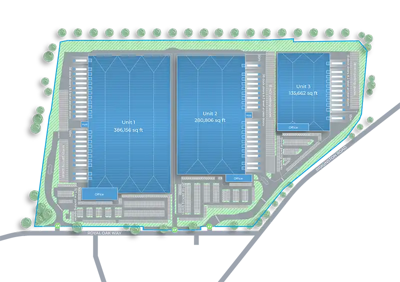
✓ Logistics parks and distribution estates Internal roads, loading bays, security gates, HGV routes and unit access mapped as connected Street View.
✓ University, corporate and public-sector campuses Campus roads, pedestrian routes, building entrances, car parks and visitor wayfinding.
✓ Hotels, resorts and destination venues Approach roads, grounds, guest arrivals, parking areas and event access routes.
✓ Councils and public-sector sites Public roads, parks, trails, visitor routes and council-managed land that Google has not covered.
✓ Retail parks and showrooms Access roads, customer parking, unit frontages and the approach to your store.
✓ Hospitals and healthcare estates Site roads, entrances, car parks and routes between buildings across large healthcare estates.
✓ Corporate offices and business parks Estate roads, visitor entrances, parking and the approach to each building.
See route mapping in practice at Logicor Park Derby and Bold 330 Manchester, where current Street View coverage helps people understand approaches, access points and estate layouts. Browse more Recent Work for examples across other sectors.
Outdoor Google Street View Pricing in the UK
Pricing depends on the size of the area and the route we cover. Single access routes and compact sites start from £986. Business parks, campus road networks, and multi-access developments start from £2,148. Logistics estates, large grounds, and trail networks start from £3,547. Final quote reflects route length, terrain, access permissions, weather conditions, and any obstructions on the day.
How Outdoor Google Street View Pricing Is Calculated
Three things drive your final quote. First, route length and coverage area: compact sites need 1 to 2 hours of capture, business parks half a day, large estates a full day or more. Second, terrain and access: gates, security clearance, height restrictions, and any private-road permissions add coordination time. Third, weather and timing: outdoor capture depends on light and conditions on the day. Standard projects fall within the tier prices above; outside-of-norm briefs are quoted individually.
What Your Quote Includes
Every Outdoor Google Street View quote covers route planning, on-site capture across the agreed area, processing and stitching, direct publishing to Google Maps, and a shareable link with embed code for your own website. There are no separate line items or publishing fees added on top.
If you are comparing companies for a road, campus, estate or trail, use our Google Street View company selection guide alongside the outdoor criteria above. It explains how to verify the provider, inspect recent published work and compare written quotations and aftercare on the same basis.
One Payment. No Hosting Fees. Permanent Listing.
You pay once. The route stays on Google Maps permanently, with no monthly hosting, no subscriptions, and no renewal invoices. That is what keeps the return on investment strong over years, not months.
Get Your Outdoor Google Street View Quote
Larger sites, complex terrain, and multi-access estates are priced individually. Send the location and a short description of the area and you will have a fixed quote back the same working day.
Verified Client Reviews Across Europe
These reviews are pulled directly from our Google Business Profile. Read all Google reviews to see what organisations say about working with us.
Trustindex verifies that the original source of the review is Google.
Gabriel at 360 Tour is a joy to work with. He works quickly and efficiently, provided the tour the following day, helped with the hosting + took brilliant photos of our gallery free of charge! if you need a 3D tour of your space then look no further. Five stars!!360 View photographed our company for Google Street View, and it has been very helpful for customers to find and see inside our business online. Highly recommended.Friendly, helpful, and outstanding service! 360 View created a virtual tour for our beauty salon in Canary Wharf, and the results are fantastic. It enables our customers to explore our salon space online in 360 degrees and persuades new clients to book with us. Since adding it, we have received numerous compliments from our clients. I only wish we had done this earlier.Our collaboration with 360 View to develop a virtual tour on Google Street View of our charming hotel overlooking Lake Garda has brought extraordinary results. The comprehensive tour captures the essence of our hotel, from the elegantly furnished rooms with their breathtaking balcony views to the terrace restaurant, which is much loved by guests. By highlighting our distinctive features directly on Google, we saw a notable 23% increase in our bookings. The virtual tour has truly proven its value, instilling trust and confidence in potential guests. Many told us that the decision to book was made easier after experiencing our hotel virtually on Google Street View. Choosing 360 View proved crucial, effectively positioning us in front of global tourists who appreciate the ability to view their accommodations before arrival. We highly recommend 360 View to any business in the tourism industry looking to increase visibility and reassure potential guests. Your guests will thank you!
(Translated by Google, see original)5 ⭐️! Gabriel at 360 View is a joy to work with. He works quickly ,efficiently and professional!The virtual tour looks amazing .Highly recommend 360 View!🥇360 View did an excelente work with the Google Street View virtual tour for our beauty salon. The Google tour lets you see every part of our salon clearly in 360 degrees. It has helped us attract new customers strait from Google Maps. Many customers said they chose us after seeing our salon on Google Street View witch proves to be a great investment. Thank you for the great work.I am an international student, and my family wanted to see the flat where I live in London. I found a 360 view online, and they created an amazing virtual tour that I could share with my family back home. My family was so happy to virtually see where I live, especially my grandparents. I am very happy with the results. If I were to move flats, I would use 360 view again.We've worked with 360 View on several projects and have never been let down once. Crystal clear image quality, fun to use, and the best virtual tour experience I've seen so far. If you are looking for a professional virtual tour company, 360 View is that company.We had an excellent experience with Gabriel, who conducted a comprehensive 360-view tour of our dental practice. His attention to detail and professionalism were outstanding. Gabriel captured every aspect of our facility with precision, showcasing the welcoming environment we strive to provide for our patients. The quality of the tour exceeded our expectations, and we highly recommend Gabriel's services for anyone seeking a top-notch virtual tour.Hello, Many businesses use virtual tours on Google to showcase the interior of their stores in 360 degrees. I hired 360 View to photograph my store in Lausanne for Google Street View, and I am extremely pleased with the high quality images and the ease of walking around the store, looking in all directions and getting a realistic perspective of our offers. I highly recommend their services. Thank you so much !
(Translated by Google, see original)My experience with 360 View was extremely good from start to end. I reached out to 360 View for a Matterport 3D Tour of my flat aiming to speed up the rental process. The result was realistic and surprisingly more enjoyable than an actual walkthrough. This digital tour significantly reduced the need for in-person visits. It even helped our new tenant from Hong Kong to confidently sign a one-year tenancy agreement without having to visit London first. I will definitely used this company again.High quality services at reasonable prices. Gabriel made a virtual tour of Matterport for us. The results were outstanding both in terms of image quality and user experience. I recommend 360 View with all confidence.
(Translated by Google, see original)Gabriel was incredibly helpful. He found a time that was suitable for us and came in and very efficiently sorted the camera work needed. He explained how it would work, sent through all the links we needed and within a day or two it was live and the outcome is awesome, we get loads of views on the virtual tour and it no doubt helps our business. 100% recommend using!360 View photographed our restaurant for Google Street View. We're all thrilled with the results and now it's easier for new customers to find us on Google. The tour helped us significantly in attracting more customers. If you need a professional Google photographer, 360 View is very professional and helpful.
(Translated by Google, see original)I recently reached out to 360 View for a Matterport 3D mapping of my home and I'm beyond pleased with the service. Seeing my house in 3D, with such detail from the floor plan to the dollhouse view and the measurement tools, has been incredibly useful for redesigning and planning the refurbishment. I highly recommend them if you're in need of a professional Matterport photographer. Their work truly stands out.On behalf of the entire team at Cuddles n Giggles, we extend our gratitude to Gabriel for his exceptional work in capturing our dog day-care and boarding venue, and its facilities. As newcomers to the online presence realm, the virtual tour has undoubtedly provided us with a distinct advantage in showcasing our services to our intended audience.Very pleased with the service these guys offering, wanted to have 360 view of my house in 3D for rental purposes and they delivered great work, pictures were clear and all is nice and smooth. They accommodate my tight schedule and traveled to Northamptonshire, Corby when it suite to me. Definitely would recommend and will use them again in the future.I had a great experience with 360 View for our Matterport virtual tour. They are very professional, and the whole process was easy. The virtual tour looks amazing, showing every detail of our place clearly. The photographer did a quick and good job. I really suggest using 360 View if you need a virtual tour. They deserve five stars!360 View created a virtual tour for our company. The virtual tour exceeded our expectations by showing the entire space in a fun and interactive way. It turned out to be very useful for us. I highly recommend 360 View for premium virtual tours.
(Translated by Google, see original)I looked for a company to create a Matterport virtual tour for my home and a friend told me about 360 View. Gabriel, the photographer, was really kind and made everything very easy. The virtual tour turned out great, high quality. Very professional and competent
(Translated by Google, see original)We hired 360 View to make a 3D Matterport model of our country house, located about two hours from Valencia, which was a great help for our renovation plans and reduced our need to travel. They provided us with AutoCAD and Revit files, invaluable to our designers. The detailed virtual tour offered a clear preview of our potential project. I highly recommend 360 View for their professional and affordable service.
(Translated by Google, see original)Our collaboration with 360 View for our restaurant's Matterport virtual tour in Milton Keynes was outstanding. Alex, our photographer, was professional and had a keen eye for detail, capturing our dining space with remarkable clarity. The 3D walkthrough has transformed our online presentation, allowing customers to explore our restaurant and familiarise themselves with our ambiance and layout before their visit. The Matterport platform's navigational ease, combined with Alex’s expertise, has elevated our marketing, setting us apart in the market. Highly recommend.Really pleased! We have had matterport virtual tour by 360 View. We had it for a property of ours. Excellent service with fast delivery. Very happy to have it delivered within a day - and easily accessible online. We would definitely use them again.As someone deeply passionate about technology, I hold a keen eye for small details and meticulous imaging. Gabriel not only met but exceeded my expectations. He left no room for flaws or corrections, showcasing his precise approach in completing the project. I am thoroughly satisfied with his work on one of my corporate office spaces in London and wholeheartedly recommend his services to those seeking high-standard 3D and Matterport visuals.360 View has created a 360 virtual tour of our office and helped us set up our Google Business profile. The photographer took about 1 hour to shoot our office, and setting up our business on Google took another 30-40 minutes. The virtual tour was available on Google Street View within 3 days, and I have to say it looks amazing. I couldn't be happier with the results. Thank you 360 View!Fantastic experience with 360 View! They offered affordable and flexible service, expertly handling photography in our hotel’s busy spaces such as the lobby, restaurants, and bars. The virtual tour they created has notably enhanced our online visibility and increased our booking rates. Highly recommended for efficient and effective service!I am very pleased with the professional help we received, from staging our flat to the virtual tour itself, which presents the property in a very good light. The photographer was very fast and professional. I will definitely use photography company again.Outstanding Matterport virtual tours! 360 View delivered high-quality service with swift and professional virtual tours for our property. Highly recommend their quick and top-notch service.Big thanks to 360 View for making a great virtual tour of our family-owned furniture store in Harringay, North London. They did an awesome job at a good price and were super quick. They even came early on a Sunday morning to avoid the crowds. The virtual tour has been a big hit with our customers and really helps us to show off what we have in our store. I definitely recommend these guys if you need a virtual tour for your business. They're fantastic!I needed a Matterport virtual tour for my flat and a friend suggested 360 View, who they had a great experience with. I was really happy with the virtual tour they made for me. The 360 pictures were clear, and it felt like I was walking through the flat myself, not just looking at it online. The virtual tour’s quality and interactive experience exceeded my expectations. I'd definitely recommend them if you want to sell your place faster.I had an outstanding experience with 360 View while showcasing my London apartment for resale. From the initial discussions to the final day of work, every step was seamless. Gabriel, the owner, not only manages the company seamlessly but also ensures the delivery of top-notch services with unparalleled professionalism and attention to detail. His remarkable responsiveness to queries and accommodation of last-minute requests truly sets 360 View apart. What's even more impressive is that all of this comes without burning a hole in your pocket (Trust me, few others I was initially talking to were about to rob me!!). I am thoroughly pleased with their services and highly recommend them to anyone seeking trustworthy and high-quality virtual tours to showcase their property or business!We run a handcrafted leather shop in Greenwich and have recently created a 360 degree virtual tour to make it easier for our clients to find us on Google. Our goal was to present our unique, handcrafted leather products in an engaging and interactive manner, displaying the variety of designs, colours, and the overall layout of our store. Additionally, we thought it would be beneficial to illustrate our store's position relative to nearby shops. The 360 View team was exceptionally supportive throughout this process. They shared valuable insights on how to prepare for the 360-degree photography session and ensured our store was showcased at its best. They skilfully crafted the virtual tour and integrated it with our Google Business profile. This integration allows anyone to virtually visit our store through Google Maps and Street View. Furthermore, their assistance in incorporating the virtual tour into our website has significantly enhanced its interactivity, resulting in increased visitor engagement. Having implemented the 360 virtual tour of our store for around six months, we have received an incredibly positive response from our clients. The tour has proved to be an effective tool for helping customers find us in Greenwich and plan their visits. We are thrilled with the results and highly recommend 360 View to any business looking to enhance their online presence.I recently needed a virtual tour for my flat in Canary Wharf, London, and chose 360 View for their use of the high-tech Matterport Pro3 camera. They really impressed me with their quality promise. Booking was easy and quick; I got an appointment for the next day. The best part? The virtual tour was all set by the next morning. A nice surprise from 360 View was the free set of 4K images they provided, taken from the tour. It was an unexpected and lovely bonus. Since I’d never asked for a virtual tour before, I thought it might be expensive. But 360 View's service was excellent and surprisingly affordable, which helped rent out my flat super fast – in just one weekend! The tour was a big hit online, with over a hundred views. It helped attract the right prospects, and although many people showed interest after seeing the virtual tour, we only needed three real-life viewings before the flat was rented. Working with 360 View wasn’t just great for their service and value; it completely changed how quickly I could rent out my property.Im the Sales and Events Manager at a hotel in East London, and I can't recommend 360 View enough for their meticulously crafted and exceptionally professional virtual tour services. They captured our hotel in 360 degrees, presenting every detail in a clean, organized, and personally tailored manner. This virtual tour has significantly boosted our sales and event reservations. The team at 360 View is not only friendly but also deeply committed to excellence, ensuring that you'll be delighted with their services. Thanks to Gabriel and his team for a job well done!We came across 360 View through a friend who had previously used and highly recommended them for their professionalism and affordability. They created a virtual tour for our property that surpassed our expectations. The image quality was crystal clear, and the virtual tour was ready in less than 24 hours. I would definitely use their services again.Gabriel at 360 View worked wonders for our store by creating a 360 tour for Google Street View. Thanks to his efforts, anyone searching for us on Google can now virtually walk through our spacious premises, getting a close look at our range of home decor and luxury furniture. This virtual peek inside has been a game-changer in drawing in more customers. For anyone in need of a Google Photographer, I can't recommend 360 View enough. Their commitment to quality images and ensuring a top-notch user experience really sets them apart.Professional, helpful and with a "contagious" friendliness! I absolutely recommend!!
(Translated by Google, see original)


Common Questions About Outdoor Google Street View
Find answers to common questions about Indoor Google Street View, how it improves local visibility, and how customers and AI assistants understand your business before visiting.
What is Outdoor Google Street View?
Outdoor Google Street View is professional 360-degree mapping for roads, campuses, estates, trails, and large outdoor environments. It publishes high-quality imagery directly to Google Maps so people can explore areas that are not currently visible or are out of date.
Can you map both private and public roads?
Yes. We map private infrastructure such as internal estate roads and campuses, and we can also update or refresh public roads that already appear on Google Maps but show outdated imagery. Many projects include a mix of both.
Can you update outdated Google Street View imagery on public roads?
Yes. If existing Google Street View imagery no longer reflects the current layout of a road or development, we can capture new imagery and publish an updated version to Google Maps. This is one of the most common reasons organisations hire us.
How do I add a trail or walking route to Google Street View?
We capture your trail or walking route as connected, GPS-accurate 360° video and publish it to Google Street View, so it appears as an explorable blue line on Google Maps. This works for footpaths, coastal paths and pedestrian routes that Google’s Street View cars cannot reach.
Why not just wait for Google to update the imagery?
Google’s own Street View capture schedule is unpredictable and cannot be booked or requested. Some locations remain outdated for many years. Our service allows you to control the timing and ensure your roads and infrastructure are updated when you need them.
How is your capture different from Google’s own Street View capture?
Google captures imagery at scale with standard routes and timing. We plan every project carefully. We choose favourable weather, low-traffic periods, and optimal lighting. We focus on important details such as signage, entrances, and access routes, creating clearer, more useful imagery for your specific environment.
What is the blue line on Google Maps, and will my route get one?
The blue line is the Street View layer on Google Maps, the same coverage Google’s own cars create. When you drag the orange Street View icon onto the map, the blue line shows where you can explore at street level. Once we capture and publish your route, it appears as its own blue line that anyone can walk or drive through online.
What types of locations can be mapped on Google Maps?
We map industrial estates, logistics parks, university campuses, business parks, new housing developments, country parks, nature reserves, national parks, walking trails, cycling routes, resorts, and any outdoor environment with roads or paths.
Where does Outdoor Google Street View appear online?
Your imagery appears directly on Google Maps and Google Search as part of the Google Street View network. Users can navigate your mapped roads and paths exactly as they do with regular Street View.
Can you add Street View coverage for council and public-sector routes?
Yes. We work with councils, local authorities, parks departments and public-sector teams to capture and publish roads, trails, pedestrian routes and council-managed land that Google has not covered or has not updated, helping residents and visitors navigate and explore these areas on Google Maps.
Can Outdoor Google Street View be embedded on our website?
Yes. Once published, the Street View imagery can be embedded on your own website, allowing visitors to explore your site directly from your pages.
Can you map hybrid projects that include both public approaches and private internal roads?
Absolutely. Many projects require updating public approach roads while also mapping private internal routes. We connect all coverage seamlessly so navigation flows naturally from the public highway into your site.
When is the best time to capture Outdoor Google Street View?
The best results are achieved during periods of low traffic and good weather. We plan capture carefully to minimise distractions, avoid busy periods, and ensure important details such as road markings and signage are clearly visible.
Do you plan captures around weather and traffic conditions?
Yes. Unlike automated large-scale capture, we schedule projects strategically. We monitor forecasts, choose quieter times of day, and plan routes to create the cleanest, most professional result possible.
How do I get a private road or gated estate onto Google Maps Street View?
Yes. Unlike automated large-scale capture, we schedule projects strategically. We monitor forecasts, choose quieter times of day, and plan routes to create the cleanest, most professional result possible.
How long does an Outdoor Google Street View project take?
Private and gated roads are rarely captured by Google because its cars only drive public roads. We capture your private road or estate route on site, process the imagery to Google’s standards, and publish it directly to Google Maps as connected Street View coverage.
Can you publish a park, protected area or visitor route to Google Street View?
Yes. We capture parks, protected landscapes, national parks, heritage sites and visitor routes as connected 360° imagery and publish them to Google Maps. Visitors can then explore the route online before they arrive, which supports tourism, accessibility and visitor planning.
How much does Outdoor Google Street View cost?
Pricing is bespoke and based on the area to be mapped, the number of roads or paths, and the complexity of the environment. Share your site details with us and we will provide a clear, no-obligation quote.
Is there an ongoing hosting fee for Outdoor Google Street View?
No. Once your imagery is published, it remains on Google Maps with no monthly or annual hosting costs.
Do you blur faces and sensitive information?
Yes. All imagery follows Google privacy standards, including automatic blurring of faces, vehicle number plates, and other sensitive details where required.
Do you need permission to map private property?
Yes. We work directly with site owners or authorised representatives to ensure full permission and access before any capture takes place.
How do we get started with Outdoor Google Street View?
Simply send us a map, aerial image, or description of the area you want to map. We will review your requirements and provide a clear capture plan and quote.
✅ Ready to map your Google Street View infrastructure?
When Outdoor Google Street View Is Not The Right Fit for you.
Outdoor Google Street View is built for connected, route-based coverage published to Google Maps. It is the right choice when people need to explore a road, trail, park, estate or campus from end to end. For some needs, another service fits better, and here is where to find it.
If you need the inside of a building on Google Maps. Outdoor Street View maps connected outdoor routes. To put the interior of your business on your Google Business Profile and Google Maps, use Indoor Google Street View.
If you need a measurable 3D model of a space. Outdoor Street View is for exploring a route, not for measurement or remote surveys. For a dimensionally accurate digital twin you can walk and measure, use Matterport Digital Twins.
If you need survey-grade measurement data. Outdoor Street View delivers visual coverage, not engineering data. For millimetre-accurate point cloud data for CAD, BIM or as-built documentation, use Point Cloud Scanning.
If you need a fully branded, self-hosted tour. Outdoor Street View publishes to Google’s platform. For a custom-branded interactive experience hosted on your own site, see Bespoke Virtual Tours.
When your goal is to make an outdoor route, trail, park, private road, estate or campus explorable on Google Maps as blue-line Street View coverage, Outdoor Google Street View is the right service. Request a quote and we will plan the capture route with you.
We Handle The Complexity You Get The Visibility
1. We Plan The Route
You don’t need to map it yourself. Share your site boundary or a map link and we design a capture route that covers every road, path, and access point for maximum navigation value on Google Maps.
2. We Capture And Build
Our team captures your environment during optimal conditions, avoiding busy periods and poor weather. We then process the data, blur faces and plates for privacy, and connect everything into a seamless Street View experience.
3. You Go Live
We publish directly to Google Maps. Your roads stay live permanently with zero monthly fees, helping visitors, drivers, and AI systems navigate your environment with confidence.
Tell Us About Your Space