A new 508,000 sq ft logistics site, mapped from the gate to the loading bays
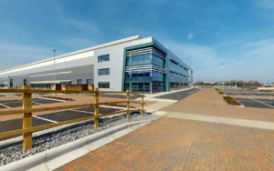
Derby 507 is a newly completed logistics facility of around 508,000 sq ft at Infinity Park Derby in the East Midlands. Developed by Logicor, it has Enterprise Zone status and holds BREEAM Excellent and EPC A+ ratings. View Derby 507 on Google Maps or visit derby507.co.uk.
Logicor asked us to put the site on Google Maps so that drivers, prospective occupiers, contractors and visiting stakeholders could see the way in before they arrived. We photographed every route that matters and published the result as connected Google Street View imagery.
Explore the Street View tour below.
The project at a glance
- Site: Derby 507, Infinity Park Derby, Pioneer Way, Derby. Around 508,000 sq ft of newly completed logistics floor area.
- Service: Google Street View Mapping. Exterior routes only, no interiors.
- Captured: main entrance, security gates, internal site roads, loading bays, parking, cycle routes and the perimeter road.
- Live: published on Google Maps with its own Google Business Profile, then live across Google Maps, Street View and Google Earth, with embed code, still images and a coverage map for Logicor’s own property page.
The problem: a finished site that Google Maps could not yet show
Google’s Street View cars photograph public roads. They do not drive private estate roads, security gates, yards or loading bays, and they come back rarely. A new development can be open for months while Google Maps still shows the plot before building started.
For a site of this scale, that gap costs time every day. Hauliers look for the right gate, visitors look for parking, and prospective occupiers try to judge access from a brochure.
What we captured: the journey in, not the building
Google Street View Mapping is about routes, so we planned the capture around the questions a first-time visitor asks. Where is the entrance? Which gate do I use? Where are the loading bays? Where do I park? Is there a cycle route?
- The approach from the public road and the main entrance
- Security gates and the internal site roads
- Loading bays and yard areas
- Car parking and cycle routes
- The full perimeter road around the site
We did not photograph the interior. Inside a warehouse unit is a separate job, either a Matterport tour or a Google Street View tour on the unit’s own Business Profile, and it can be added when a unit is being marketed.
Premium navigation: every viewpoint connects
Good Street View mapping depends on navigation as much as on photography. We used high-quality professional 360 cameras, placed a viewpoint at every junction, gate and bay, and connected the imagery so you can follow the route on screen from the public road to the loading bay without a jump. Faces and number plates are blurred before anything is published.
The finished coverage is found the way any road is found: by dropping the Pegman on Google Maps, by following directions, or through a direct link.
Two decisions that made the tour useful from day one
We set up the Google Business Profile for Derby 507 before publishing, so the imagery had a home on Google Maps from the first day it was live.
We also noticed that the address in the sales brochure did not match the pin on Google Maps, and flagged it. The first visitor to trust the map arrived at the right entrance on Pioneer Way.
From photography to live on Google Maps
- Photography: every agreed route captured on site, from the entrance to the loading bays.
- Publication: the Street View tour published and the Google Business Profile set up.
- Handover: fully live across Google Maps, Street View and Google Earth, with embed code, still images and a coverage map delivered to Logicor.
Most Street View sites are live on Google within 5 to 7 working days of photography. Very large or multi building projects are scheduled individually, and we agree the timing before we start.
One of five Logicor sites, with more since
Logicor Park Dartford came first: one Matterport model connecting 20 industrial units across three buildings. Logicor Park Daventry followed, with exterior Street View across a development of three warehouses totalling 800,000 sq ft. Derby 507 came next, with a simple brief: do the same as Daventry.
Since then we have mapped Logicor Park Altrincham and Bolt 330 in Bolton. Each site is a separate commission, and each one is planned around its own routes, gates and yards.
What this means for your estate, campus or development
If you are launching a site that people need to find, the sequence is the same. Plan the routes, photograph them properly, connect the imagery, give it a home on Google Maps and hand over embed code for your own pages.
This is our Google Street View Mapping service. It is priced by route length rather than floor area, and current pricing is on the service page. For warehouse interiors, see Matterport Virtual Tours, and for more projects in this sector see virtual tours for logistics and industrial sites.
Frequently asked questions about Google Street View mapping for logistics sites
What is Google Street View Mapping, and how is it different from a Google Street View tour of a business?
Google Street View Mapping by 360 View covers roads, paths and routes across an estate, campus, park or development, and publishes them to Street View itself, so anyone exploring Google Maps can follow them. A Google Street View tour of a business shows one venue, inside and immediately outside, and is published to that venue’s Google Business Profile. The two can be combined on the same site.
How long does Google Street View mapping take for a logistics site like Derby 507?
Most sites are live on Google within 5 to 7 working days of photography. Very large or multi building projects are scheduled individually, and we agree the timing before we start.
Does Google Street View mapping show inside the warehouse?
No. Street View mapping covers the exterior routes: entrances, gates, roads, yards, parking and cycle paths. Interiors are a separate tour, either a Matterport virtual tour or a Google Street View tour on the unit’s Business Profile. A site is quoted by the length of the routes to be covered, not by floor area.
Who controls what the Street View imagery shows?
You do. You choose the routes before 360 View photographs them, restricted areas can be left out, and faces and number plates are blurred before publishing. 360 View manages the publication and can arrange updates to the imagery it manages as the site changes.
Is there a monthly fee for Google Street View mapping?
No. Once published, Google hosts the Street View imagery at no ongoing cost. The same imagery can be embedded on your own website and used in marketing material.
Can we use the Street View imagery on our own property website?
Yes. For Derby 507, 360 View delivered embed code, still images and a coverage map so Logicor could use the tour on its own property page alongside the brochure and site plan.
Launching a site that people need to find?
Tell us about the estate, the routes and the deadline. We work across the UK and Europe with no travel fees, and we can quote from a site plan or a short video call.