Large buildings and complex sites need more than simply placing a 360 camera around a space.
360 View plans and creates Matterport virtual tours, Google Street View mapping, bespoke 360 experiences and spatial capture solutions for large buildings, multi-building estates, offices, logistics parks, universities, hospitals, entertainment venues and other complex environments across the UK.
For these projects, the challenge is rarely just the number of square feet.
We need to understand how buildings connect, who will use the finished virtual environment, which areas can be public or private, how people actually move through the site and how the capture can be completed safely around normal operations.
Sometimes that means working around staff, contractors and visitors. On other projects, the right solution is to reserve an entire building or venue exclusively for the capture.
Our role is to plan all of this before and during the project so that a very large physical environment becomes simple to understand and easy to explore digitally.
Planning a large or complex virtual tour project?
Send us the site location, approximate size, floor plans if available and what you need the finished project to achieve. We can recommend the most appropriate capture and delivery approach.
Experience Across Large and Complex Environments
Our experience includes:
20 unit industrial developments with warehouses, offices, facilities, parking, internal roads and direct navigation to individual available units.
Multi-building public sector offices captured over several days and divided into connected Matterport models for internal planning, refurbishment and staff use.
Large university buildings captured internally and externally to support refurbishment, construction logistics and estate planning.
Hospitals and healthcare environments where privacy, operational disruption and access require careful planning.
Large entertainment and sports venues where secure access, confidentiality, health and safety and tightly controlled capture windows are critical.
Some of these environments can be shown publicly. Others were commissioned for internal operational use and cannot be displayed online.
The planning principles are the same in both cases.
Large Spaces Need More Than More Scans
A 90,000 sq ft warehouse, a ten floor office building, a university campus and a major entertainment venue may all be large spaces, but they cannot be approached in the same way.
Before deciding how to capture a site, we first establish what the finished virtual environment needs to achieve.
Who will use it?
Do they need to understand one building or several?
Should the tour be publicly accessible or restricted to authorised teams?
Do users need measurements?
Are external roads, parking, loading areas or gardens relevant?
Do multiple buildings need to connect?
Are there secure or restricted areas?
Will the building remain operational during capture?
Does someone need to reach one specific warehouse unit without navigating through an entire estate?
These questions influence how the project is divided, how many models may be required, where users should enter and how different parts of the site are connected.
For very large projects, good navigation can be as important as good image quality.
Planning Around Real Buildings, People and Operations
Large operational buildings are rarely empty and waiting for us to arrive.
Staff continue working. Meetings and events take place. Contractors move equipment. Deliveries arrive. Different departments require access to different areas. Some spaces may become available for only a short period during the day.
This is why large virtual tour projects require coordination as well as capture expertise.
Multi-building Matterport project for Bromley Council
A good example is our work with Bromley Council.
The council was going through a significant internal reorganisation involving office moves and the use of a new town centre location. We were commissioned to create Matterport digital twins across several large and interconnected buildings for internal operational use.
The environment included multiple office buildings, numerous floors and interconnected parking areas with different access points.
One building alone extended across more than ten floors.
The finished digital twins were required for purposes including office planning and allocation, refurbishment work, internal coordination and helping staff understand spaces as teams moved between council locations.
Trying to force the entire environment into one enormous Matterport model would not necessarily have produced the best user experience.
Instead, we divided parts of the environment into several carefully planned models and created logical connections between them.
When a user reached a connecting point between buildings, they could move into the corresponding model for the next building. If they returned through that connection, they could move naturally back into the previous environment.
Each model retained its own detailed 3D Dollhouse view while the overall journey remained logical for the user.
The capture itself required careful coordination.
Different floors had staff working, events taking place and contractors moving equipment. We worked with operational teams to establish when particular areas could be captured.
Rather than allowing one busy floor to stop the whole project, we moved between buildings and areas according to availability.
Across five days we progressively completed the required environments while prioritising capture during the day so that the spaces benefited from natural light wherever possible.
The camera was only one part of delivering this project successfully.
Planning and coordination made the capture possible.
You can read more about our Matterport work with Bromley Council and our wider approach to virtual tours for government and public sector buildings.
Making Very Large Virtual Tours Easy to Navigate
One of the biggest mistakes with a large virtual tour is assuming that every user should begin in the same place and navigate through the entire environment to find what they need.
On a small property that may work perfectly.
Across an industrial estate containing many independent units, it can create unnecessary friction.
Logicor Park Dartford
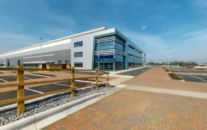
At Logicor Park Dartford, we captured approximately 82,000 sq ft of internal commercial space across 20 units, together with the surrounding roads, parking and external circulation areas, bringing the overall captured environment to approximately 200,000 sq ft.
The project included far more than the warehouse floors.
Depending on the individual unit, the capture included offices, entrances, kitchens, showers and changing facilities, external circulation areas, parking and the roads running through the development.
The estate also needed to accommodate different types of users and vehicles, including private cars and large commercial vehicles.
Each industrial unit needed to work as an individual property while remaining part of the wider development.
We therefore created direct navigation to individual units rather than requiring prospective occupiers to enter one large virtual environment and search for the warehouse they wanted to see.
We also developed a personalised website navigation and embedding approach so that individual available units could be presented directly from the client’s property website.
This means someone interested in a particular available unit can open that space directly and explore the warehouse, office and associated facilities without first navigating through unrelated areas of the development.
It makes the experience faster, clearer and less frustrating.
It also gives the property team flexibility as availability changes. The website can focus attention on the units currently being marketed rather than requiring every visitor to navigate the entire estate.
You can see this approach being used on the live Logicor Park Dartford website, where individual available units can be opened directly as Matterport virtual tours.
This project is also a good example of our wider approach to virtual tours for warehouses and industrial sites.
For very large properties, capturing the space is only half of the work.
The other half is making the resulting information usable.
On a large site, visitors should not have to walk the whole tour to find one building or unit. We add Virtual Tour Space Navigation to large Google Street View and Matterport tours, so each building, floor or unit is one click away on your website, from £49.
Some Projects Need Coordination. Others Need the Site Reserved Completely.
Not every operational environment can be captured in the same way.
For the Bromley Council project, the practical solution was to coordinate around staff, contractors, meetings and other activity, moving between available areas throughout the day.
For one of our large London entertainment venue projects, the requirements were completely different.
The venue normally operates almost every day. Shows, rehearsals, technical preparations, maintenance and other work mean that numerous teams are normally present throughout the building.
Trying to capture a complex Matterport model around that level of movement would have compromised the consistency of the finished model and made the work considerably more difficult.
The capture therefore had to be planned approximately two months in advance so the venue could reserve the required period for us and suspend normal activity across the areas being captured.
The main capture took two full days.
Even with that preparation, several specialised areas could not be completed during the main capture.
Certain passages and lift areas required assistance from a qualified lift operator. The lift systems involved open platform style equipment, so health and safety requirements meant that these areas could not simply be accessed independently.
We returned for a short third visit and worked with the operator to complete the remaining connections safely.
That may represent only a small part of the final Matterport model, but it illustrates something important about large-scale capture.
Completing a complex virtual environment properly sometimes depends on coordinating people, specialist access and safety procedures that have very little to do with operating a camera.
We determine these requirements with the client before capture wherever possible.
You can read more about our approach to a private Matterport project for a large London entertainment venue.
Public and Private Virtual Tours
A large virtual tour does not automatically need to be published on a website or Google Maps.
Some of our largest Matterport projects were commissioned specifically for internal use.
For major entertainment and sports venues, for example, the digital twin may contain operational areas, technical spaces, staff facilities, circulation routes and other information that the organisation does not want publicly accessible.
Security therefore becomes part of the project from the beginning.
Before capture, we can agree what should be included, what should remain outside the model and who ultimately needs access.
The completed Matterport environment can then be configured for controlled use rather than public marketing.
This approach can also be appropriate for government organisations, corporate offices, construction projects, healthcare facilities and other operational environments.
Some of the most complex spaces we have captured will therefore never appear in our public portfolio.
We see that as part of professional project delivery.
Respecting a client’s confidentiality and security requirements is more important than being able to use every project for marketing.
Virtual Tours for Refurbishment and Construction Planning
Large virtual tours are not only marketing tools.
They can become practical spatial references for architects, designers, contractors, facilities teams, estates departments and project managers.
London Business School
For London Business School, we captured approximately 48,700 sq ft of internal space across several floors, plus around 30,000 sq ft of external areas including the loading bay, parking, gardens and connecting pathways. This brought the overall captured environment to approximately 78,700 sq ft.
But the useful environment did not stop at the building entrance.
We also captured relevant external areas including the loading bay, parking areas, gardens and connecting pathways.
For a refurbishment or construction project, those external areas can be just as important as the rooms being redesigned.
Project teams may need to understand how materials can arrive, how contractors reach the building, how existing pathways connect, where temporary equipment could potentially be positioned and how different parts of the site relate to one another.
A detailed virtual representation allows teams to return to the existing environment remotely when discussing these questions.
Instead of travelling back to site every time someone needs to confirm a basic spatial detail, the digital twin can provide a shared visual reference for planning and communication.
This type of project demonstrates why we think beyond simply capturing attractive rooms.
The surrounding operational context can be equally important.
Choosing the Right Technology for a Large or Complex Space
We do not begin a complex project by assuming that every organisation needs the same technology.
The right capture method depends on what people need to understand or accomplish.
Matterport Digital Twins
Matterport digital twins are particularly effective when users need to understand interiors remotely.
People can move through rooms and floors, switch to a 3D Dollhouse or floor plan view, inspect details and understand how different areas connect.
Depending on the project, Matterport can support property marketing, refurbishment planning, facilities management, internal familiarisation, measurement, remote collaboration and documentation of existing conditions.
For very large sites, we decide whether the environment works best as one model or as several connected models.
A larger model is not automatically a better model.
The structure should support the way people need to use it.
Google Street View for Large Sites and Estates
For campuses, logistics estates and other environments where users need to understand the wider site, Outdoor Google Street View can be particularly valuable.
Google’s standard Street View coverage often ends at the public road.
Private estate roads, internal routes, campus paths, loading areas, car parks and individual building entrances may remain unmapped.
We can capture these routes and publish connected Street View coverage to Google Maps so visitors, contractors, drivers and other users can understand the site before arriving.
Matterport and Google Street View Together
For some large projects, neither platform solves the whole problem independently.
A logistics development is a good example.
Matterport can provide a detailed representation of individual warehouse interiors, offices and facilities.
Google Street View can help people understand the external roads, estate entrances, parking and relationship between the different buildings.
Using the two technologies for different purposes can create a much more useful representation of the overall environment.
Bespoke Virtual Tours
Some organisations require greater control over branding, navigation, information and the way different environments are connected.
In these situations, a bespoke virtual tour can provide a customised interface rather than relying entirely on a standard third-party platform.
This can be particularly useful for campuses, cultural environments, visitor destinations and other projects where the experience itself needs to follow a particular user journey.
Point Cloud and Spatial Data
Where a project requires spatial data for architectural, construction, CAD or BIM workflows, we can also discuss point cloud scanning and associated technical outputs.
The appropriate capture method and deliverable depend on the accuracy requirements and what the data will ultimately be used for.
Large Virtual Tour Projects Across Different Sectors
The principles we have learned from large and complex projects apply across many different types of environment.
Logistics and Industrial
Warehouses, offices, loading areas, parking, yards, vehicle routes and multiple individual units may all need to work together as one digital environment.
Our work with Logicor demonstrates how Matterport interiors, external capture, direct unit access and customised website navigation can support both property marketing and a clearer understanding of a large estate.
Government and Public Sector
Large public sector environments can involve numerous floors, interconnected buildings, parking, restricted areas and spaces that must remain operational during capture.
Our work with Bromley Council demonstrates how multiple Matterport models can be planned around operational activity and connected to support internal use.
Universities and Education
Universities and colleges can combine teaching spaces, offices, external areas, loading routes, landscaped areas and several connected buildings.
Our London Business School project demonstrates how a digital twin can support refurbishment and estate planning rather than simply providing an online tour for prospective students.
Hospitals and Healthcare
We have completed virtual tour projects for private hospitals and healthcare environments in London and Manchester.
Healthcare projects require particular consideration around privacy, operational disruption, appropriate areas for capture and how the finished virtual environment will be used.
For larger hospitals and healthcare campuses, Matterport, Google Street View and other forms of spatial capture can serve very different requirements.
You can explore our wider approach to virtual tours for hospitals and healthcare facilities.
Entertainment and Sports Venues
Large venues can contain public areas, operational spaces, technical environments, back of house routes and restricted sections within the same building.
In some cases, capture needs to be coordinated around normal operations.
In others, the venue must be reserved and normal activity suspended.
Security and controlled access to the final model can also be more important than public visibility.
Commercial Offices and Workspaces
Large office environments may need digital twins for workplace planning, refurbishment, allocation of teams, facilities management, relocation projects or remote collaboration.
Multi-floor and multi-building offices particularly benefit from careful model planning and logical connections between different environments.
Construction and Refurbishment
Digital twins can provide project teams with a visual record of an existing building before and during planned works.
Internal layouts, loading areas, access routes, parking and external circulation can all be relevant when contractors and project teams need to understand the wider site rather than an individual room.
How We Plan a Large Virtual Tour Project
Every project begins with understanding what the organisation needs the finished virtual environment to do.
Floor plans are particularly valuable.
They allow us to understand the number of floors, approximate scale, connections between buildings, access routes and areas that may need special consideration before we arrive.
We then decide how the environment should be structured.
For a large Matterport project, this can include deciding whether the site should remain as one model or be divided into several connected environments.
For a Google Street View project, it may involve identifying the important roads, pedestrian routes, entrances, parking areas and points where users naturally enter the site.
For an operational environment, we establish how capture can work around normal activity.
Sometimes this means coordinating particular floors or departments at specific times.
Sometimes it means moving between buildings during the day depending on which areas become available.
And sometimes, as with one of our large entertainment venue projects, the correct approach is to reserve the site and prevent other activity during the main capture.
Safety requirements, access restrictions and specialist areas are also considered before and during the work.
Once capture is complete, we review the models and connections, configure the required navigation and prepare the agreed outputs.
The objective is not simply to record every square metre.
It is to make a complex physical environment understandable to someone who may never have visited it before.
One Large Building, Multiple Buildings or Multiple Locations
These are three different project types.
A single very large building may need to be organised around floors, departments or operational areas.
Several connected buildings require logical transition points so users understand how one environment relates to another.
A portfolio covering numerous separate locations requires consistency, so each site follows an agreed capture and presentation standard even though the individual properties may be very different.
We plan the structure around the organisation and the intended use rather than forcing every project into the same template.
Why Navigation Matters More as a Project Gets Larger
A technically complete virtual tour can still provide a poor experience if people struggle to find what they need.
As a project grows, navigation needs to become more deliberate.
Someone exploring an individual warehouse should not have to walk virtually through numerous unrelated units first.
A member of staff moving between office buildings should understand when they have entered a different building.
Someone arriving at a logistics estate should be able to understand the relationship between the public road, estate entrance, internal roads and the unit they are looking for.
This is why we consider starting positions, direct links, connections between models, labels, information points and website integration as part of large project planning.
The best solution is not necessarily the virtual tour containing the most scans.
It is the one that makes a complicated environment feel simple.
What We Need to Assess a Complex Project
For an initial assessment, the most useful information is:
- the site address or locations
- approximate floor area
- number of floors and buildings
- floor plans if available
- what the finished virtual tour will be used for
- whether it should be public or private
- whether external areas need to be included
- known access or security restrictions
- preferred project dates
- any specific outputs required
If no floor plan is available, we can usually begin with approximate dimensions, existing plans, photographs, videos or a discussion with the relevant project or facilities team.
For operational environments, we can also discuss working hours, staff activity, events, contractor access and whether particular areas need to be reserved for capture.
Experience Matters More as Projects Become More Complex
Capturing a small empty commercial space and digitising a large operational environment are very different projects.
As scale increases, the quality of the camera remains important, but planning, communication, access, navigation, health and safety and quality control become increasingly important too.
Our experience includes multi-building public sector offices, large industrial estates, university buildings, hospitals, commercial properties and major entertainment and sports venues.
Some of those projects can be explored publicly.
Others were commissioned specifically for secure internal use and cannot be shown.
Both types of work have helped us understand how organisations actually use virtual environments after the cameras have left the site.
That experience influences how we approach the next project.
We first understand what you need people to see, understand or do.
Then we plan the capture around the real environment.
We select the appropriate technology.
We make the finished experience easy to navigate.
And we remain available after delivery when the space, availability or requirements change.
You can explore more virtual tour and spatial capture projects completed by 360 View.
Frequently Asked Questions
How do you decide whether a large site should be one Matterport model or several connected models?
We base this on the building layout, number of floors, connections between spaces and how people will use the finished tour. One very large model is not always the best experience. On multi-building projects, we have created separate Matterport models connected at logical transition points so users can move naturally between buildings without making navigation unnecessarily complicated.
How do you capture a large building that needs to remain operational?
We plan the capture around the way the site actually works. This can mean coordinating individual floors with operations teams, moving between buildings as areas become available and scheduling around staff, contractors, meetings or deliveries. On one multi-building public sector project, this approach allowed us to complete the capture over five days without requiring the entire estate to close.
When does a large venue need to be closed specifically for the virtual tour capture?
If constant movement, safety requirements or operational activity would compromise the capture, reserving the site may be the better solution. For one large London entertainment venue, the capture was planned around two months in advance so normal activity could be suspended for two full capture days, with a short additional visit required for areas that could only be accessed safely with a specialist lift operator.
How do you prevent users getting lost in a very large virtual tour?
Navigation is planned as part of the project rather than added afterwards. We consider starting locations, direct links, connections between models and how users are most likely to search for a particular area. At Logicor Park Dartford, individual available units can be opened directly instead of making prospective occupiers navigate through an approximately 200,000 sq ft captured environment to find the space they want.
Can one project include buildings, roads, parking and other outdoor areas?
Yes, and on many complex sites the external environment is essential to understanding the buildings. At Logicor Park Dartford, approximately 82,000 sq ft of internal space formed part of an overall captured environment of around 200,000 sq ft once roads, parking and external circulation areas were included. At London Business School, approximately 48,700 sq ft of interiors were captured alongside roughly 30,000 sq ft of relevant outdoor space.
How do you approach a site with several connected buildings?
We first establish how people physically move between the buildings and which connections need to make sense digitally. Depending on the site, this may involve several Matterport models connected through doorways or other logical transition points. The objective is for users to understand when they have moved into another building while keeping the overall experience natural and easy to follow.
Can large virtual tours be created for internal planning rather than marketing?
Yes. Many of our most complex projects were commissioned for internal purposes such as refurbishment, workplace planning, staff relocation, facilities coordination and construction planning. In these situations, usefulness, security and an accurate understanding of the space can be considerably more important than creating a public-facing marketing tour.
How do you handle secure or restricted areas on complex projects?
Security requirements are discussed before capture so we can agree what should be included, excluded or kept private. Some of the largest entertainment, public sector and operational environments we have captured cannot be shown in our public portfolio because the resulting models were created specifically for authorised teams. Protecting those requirements is part of delivering the project professionally.
What information helps you plan a large or multi-building project?
Floor plans are particularly useful because they help us understand scale, floors, building connections and potential capture routes before arriving on site. We also look at the intended use, operational hours, restricted areas, external spaces, required outputs and whether staff or contractors will remain present during capture. For complex projects, this planning stage can be just as important as the scanning itself.
Can Matterport and Google Street View be used together on a large site?
Yes. On some sites, each technology solves a different part of the problem. Matterport can provide detailed interior exploration of individual buildings while Google Street View can help users understand external roads, entrances, parking and movement around a wider estate. For logistics parks, campuses and similar environments, combining them can create a much more complete representation of the site.
Planning a Large or Complex Virtual Tour Project?
If you are responsible for a large building, campus, industrial estate, healthcare facility, venue, public building or multi-site property portfolio, tell us what you need to achieve.
Send us the site location, approximate area and floor plans if available.
If plans are not available, send us the information you already have and we can help establish what is needed.
We will review the project and recommend the most appropriate approach, whether that involves Matterport, Google Street View, bespoke 360 capture, spatial data or a combination of technologies.
Tell us about your project and we will help you plan the right solution.